Westchester, 1938
- Tuesday, 27 March 2012 15:18
- Last Updated: Tuesday, 27 March 2012 15:21
- Published: Tuesday, 27 March 2012 15:18
- Hits: 5618
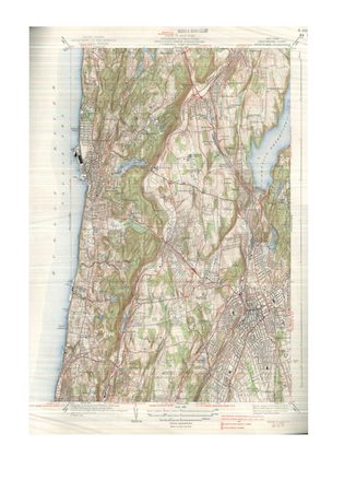
 SHS grad Jordan Spitzer is now a student at Cornell University where he came upon a 1938 map of Westchester County. Below is his analysis of transportation in the county, then and now: The Village of Scarsdale, with its five unique neighborhoods and outstanding schools, has over 300 years of history. While hard to imagine, Scarsdale did not have paved roads in its colonial days; the village was not much more than land with estate properties that would be later subdivided. Since then, Scarsdale has grown to become a fascinating cultural center, with landmark buildings and interesting residents, including both Yoko Ono and Linda Eastman McCartney. However, this dynamic change did not simply occur overnight.
Not more than 75 years ago, Westchester County as we know it was not the same place by a long shot. Thanks to the New York State topographical maps made available by The State University Of New York College Of Agriculture And Life Sciences Cornell University, we can identify several key differences and interesting facts about Westchester County, circa 1938:
1 - There are no interstates. I-87 (NYS Thruway) and I-287 (Cross Westchester Expressway) would not be built and completed for another 30 years or so, after Eisenhower
2 - Bloomingdale Road was not eponymously named for the department store, but rather the little known Bloomingdale Asylum that is currently located next to the department store. This explains why the store looks like an asylum - it used to be one. Westchester Penitentiary also exists nearby present day Westchester Medical Center and New York Medical College in Hawthorne.
3 - Mamaroneck Avenue used to be a labeled state highway, NY-126. Now it only exists as Westchester County Route 8. This is a small detail, but it explains why Mamaroneck Avenue is still to this day one of the most important roads in the southern part of the county.
4 - Scarsdale was not yet a center of any kind, but rather simply a rural village that served as a connection between Mount Vernon and White Plains. Note that NY-125, currently Palmer Avenue in Scarsdale and Weaver Street in Scarsdale and New Rochelle, does not yet exist on this map; instead NY-126 (Mamaroneck Avenue) serves its purpose, indicating the greater importance of Mamaroneck over Scarsdale and New Rochelle. There are no roads leading directly from White Plains to New Rochelle, two of the county’s largest cities. Also missing from the map are other towns along the Bronx River such as Eastchester, Tuckahoe, and Bronxville. Hartsdale. While today Scarsdale’s town center is located on the Bronx River, at this time, only the four corners at NY-100 are of any importance.
5 - There are multiple major roads leading to Dobbs Ferry, Irvington, and Tarrytown, some of which are yet to be labeled derivatives of NY-100. Today, there are fewer major roads leading to the Hudson River towns, as many have been replaced by limited access residential roads, especially those to Irvington. Also note that as there is no New York State Thruway and no Tappan Zee Bridge. In fact, the only way to get to what was rural Rockland County was by ferry boat from Tarrytown and Irvington. Dobbs Ferry, ironically, did not have such ferry services.
6 - There is also another train line on the map that ended in White Plains, This line is now defunct, but remnants of it can still be spotted in parts of White Plains and Scarsdale, most notably at the current office of Engel & Voelkers Real Estate, formerly the Scarsdale SVAC, and even more formerly, the Heathcote railroad station.
7 - The Sprain Brook Parkway was also yet to be built. The Hutchinson River Parkway and the Bronx River Parkway, respectively the world's second and first parkways ever, are already there. The Bronx River Parkway exceeded its current boundaries onto what is now known as the Taconic State Parkway, and served as the main route from White Plains to northern Hudson River towns, most notably Briarcliff Manor, Ossining, and Peekskill.
8 - Port Chester, Rye, and Fairfield County were accessible via Westchester Ave and the route that is now I-287. The map survey however does not cover the eastern portions of the county.
9 - New York City (Bronx and Manhattan) were easily accessible through US-9 (Albany Post Rd), US-1 (Boston Post Rd), NY-100 (Central Park Ave), NY-22 (New York Post Rd), and of course, the Bronx River Parkway.
10 - New Jersey was still not directly accessible from Westchester County. I guess no one in Westchester ever cared about New Jersey.
Jordan Spitzer is a student at Cornell University and a former student at Scarsdale High School. He can be reached at jrs429@cornell.edu with any thoughts or questions.


